Our Services
GIS & DRONE SERVICES
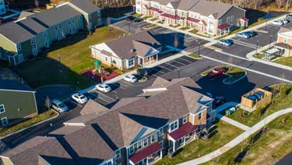
Using our Smart Site Plan™ technology, RAUCH inc. has developed the most advanced asset management tool to enhance projects by improving informed decision-making and increasing data accessibility throughout the entire project life cycle. We make our data available in a powerful interactive web app accessible anywhere.
Aerial Survey & Mapping
Our FAA Part 107 certified pilots operate professional-grade drone platforms to capture data faster and more affordably than traditional methods. What used to take a survey crew weeks can now be mapped in days, with higher resolution and broader coverage.
- Up-to-date aerial imagery
- Detailed topography mapping
- Drainage area identification
- Construction progress tracking
- Volume calculations
- Thermal inspection using FLIR
GIS & Spatial Analysis
We build geographic information systems that turn raw data into actionable intelligence. Whether it's a county-wide parcel database or a utility asset management system, our GIS analysts create tools that help organizations make smarter decisions about their land and infrastructure.
- Real-time GIS model for water, wastewater & stormwater utilities
- Fire hydrant, cleanout, and water meter tracking
- Emergency preparedness planning
- Utility system maintenance planning
- Construction upgrade coordination
- Subdivision planning support
3D Building Reconstruction
Combining aerial survey, GIS data, and 3D modeling, we create digital representations of real-world environments. These digital twins support planning, design review, and stakeholder communication in ways that flat drawings simply can't match.
Get in touch
Have a gis & drone services project in mind?
Every project starts the same way: with a conversation about what matters most to you. Let's sit down and talk about yours.
Other services